
At a Glance
In recent years, commercial investment in space has greatly increased, with emphasis on low altitudes—about 300 kilometers (km) to 2,000 km (or roughly 190 miles to 1,240 miles) above the Earth. Today, several companies plan to build and launch very large constellations of satellites in orbits at those altitudes. Similarly, the Department of Defense (DoD) has begun to plan for new large constellations of satellites at lower orbits to make the performance of their satellite missions more resilient against interference and attack by adversaries.
In this report, the Congressional Budget Office provides an introduction to the advantages of and challenges for constellations of low-altitude satellites. In particular, the report describes the effects that orbital altitude has on the design of satellites and constellations of those satellites, focusing on DoD’s Earth-observation and communications missions. The highlights of that review include the following:
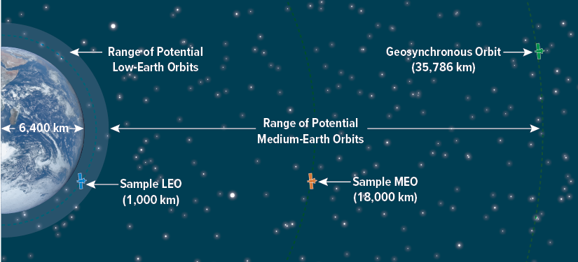
- Most satellites operate in roughly circular orbits between about 300 km and about 36,000 km above the Earth. Those orbits are separated into three categories: Low-Earth orbits (LEOs) range from 300 km to 2,000 km above the Earth’s surface; medium-Earth orbits (MEOs) range from 2,000 km to about 35,000 km; and geosynchronous orbits (GEOs) operate at 35,786 km.
- Satellites in LEO generally are smaller, cost less, and have shorter operational lifetimes than those at higher altitudes. More LEO satellites are generally needed to achieve coverage comparable to smaller constellations at higher altitudes, and the LEO satellites need to be replaced more often to maintain the constellation.
- Operating in LEO potentially allows for more timely communications, higher resolution imagery, and, for large constellations, greater resilience against attack or interference because many satellites share the same mission. However, LEO satellites can view a given point on Earth for only about 10 minutes, making constellation management more complex if continuous communication or observation is required.
- The costs of maintaining LEO constellations for many years are potentially higher than MEO or GEO constellations with comparable coverage, but LEO costs could be reduced if mass production significantly decreased unit costs or if launch costs continued to decline.
Notes
All years referred to in this report are federal fiscal years, which run from October 1 to September 30 and are designated by the calendar year in which they end. All costs are in constant fiscal year 2023 dollars.
Figures in this report showing satellite orbits were generated by the Congressional Budget Office using Systems Toolkit, a software package produced by Ansys Government Initiatives (AGI).
The cover was illustrated by R. L. Rebach and depicts an artistic rendering of the view from a satellite in a large constellation in low-Earth orbit.
For more than 60 years, the United States has operated satellites in orbit around the Earth. Today, several U.S. government agencies, including the Department of Defense (DoD) and the National Aeronautics and Space Administration (NASA), operate satellites, as do many foreign countries and numerous commercial companies. According to a recent study, about 5,000 operational satellites were in orbit as of January 2022. Many of those satellites operate as part of constellations. (A constellation is a group of satellites, ranging from a few to hundreds or more, that collectively perform a particular mission.) The number of satellites in orbit is expected to skyrocket over the next decade, mostly because of the fielding of a number of new large constellations of commercial satellites orbiting at relatively low altitudes.1 In this report, the Congressional Budget Office provides an introduction to the basics of satellites and constellations, describes the reasons for and consequences of the projected growth in large constellations, and discusses the costs of fielding those constellations.
Satellite Basics
Satellites are complicated technical devices, designed and equipped to perform specific missions while in orbit. A satellite’s mission and orbital altitude determine the capability of the equipment needed on board. Each type of mission requires specific equipment. For example, satellites with Earth-observation missions need telescopes with varying features, whereas communications satellites require equipment that can receive and transmit signals to users on the surface of the Earth and to other satellites in orbit.
Common Categories of Satellite Missions
Most satellites perform missions that fall into one of three categories: Earth observation, navigation, or communications.
There are several different types of Earth-observation missions. One common type of mission is the identification and monitoring of environmental phenomena, such as weather, wildfires, and polar ice caps. NASA’s Earth Observing System, for example, employs a variety of satellites equipped with telescopes, including the Landsat series, which collects imagery of Earth’s surface, for such purposes.2 Another type of Earth-observation mission is the surveillance of activities by foreign nations that present potential national security threats. DoD’s Space-Based Infrared System, for example, monitors the globe to detect and characterize missile launches. The specific features of the equipment depend on the mission: Detecting environmental trends may only require resolutions (the distance between objects at which they can be visibly distinguished from each other) measured in kilometers (km); by contrast, detecting new military equipment may require resolutions of a few meters (m) or tens of centimeters.
Navigation missions allow users on Earth to determine their location by receiving signals from multiple satellites. DoD initially constructed the Global Positioning System (GPS) satellite constellation to support military navigation, but its use has become widespread for the public as well.
Communications missions have several common applications, including satellite phones (such as Iridium, Globalstar, and Inmarsat), television and radio (such as Dish and SiriusXM), and, more recently, internet access (such as Viasat and Starlink). In addition, many military applications rely on both military and commercial satellites for voice and data communications. Those satellites generally have equipment that receives a signal from a user and then relays that signal to the designated recipient.
How Satellites Stay in Orbit
The trajectory of an object above the surface of the Earth is determined by the gravitational pull of the Earth and the object’s initial velocity (that is, the direction and speed of its motion). Objects in orbit around the Earth travel along a path that balances the motion so that the object does not move closer to the Earth’s surface. (The following description is somewhat idealized to make it easier to explain.)3
The force of gravity decreases as the distance between two objects increases. Therefore, the acceleration ( ) caused by the Earth’s gravitational pull on an object in space decreases quickly as the object’s height above the surface of the Earth (that is, its altitude) increases. For example, at 1,000 km altitude, is about three-quarters of the acceleration on the Earth’s surface; at 36,000 km altitude, it is about one-fifth of the acceleration on the surface. Consequently, the closer the object is to the surface of the Earth, the farther it will fall in a given amount of time.
While gravity is pulling an object toward the Earth, its initial velocity is propelling it across the Earth’s surface. If that velocity is just right, even though the object has fallen, it will also have moved across the Earth’s surface, so it will not be any closer to Earth. When that happens, the object is said to be in orbit. Because of the effect of altitude on the acceleration caused by gravity, the initial velocity needed to maintain an orbit is higher for objects at lower altitudes.
Effects of Altitude and Initial Velocity on a Satellite’s Trajectory

Gravity always pulls objects toward the Earth (top left panel). An object’s initial velocity across the surface of the Earth determines what happens in addition to its falling. If the velocity is too low, the object will move across the surface but still hit the Earth (top right panel). If the velocity is too high, it will miss the Earth and travel into space (bottom left panel). If the velocity is just right, it will trace a circle around the Earth and return to the same original spot, a path known as an orbit (bottom right panel).
Satellite Function and Design
Satellites are made up of a mission-specific payload (such as a telescope or other sensor, a communications package, or precise clocks that allow users to determine their position) and the satellite bus, which houses equipment that enables the payload to execute its mission. That equipment typically includes a structure to hold the various devices and an enclosure to shield them from the space environment, a power source (generally solar panels), equipment for thermal control (to regulate the satellite’s temperature as it passes into and out of the Earth’s shadow), batteries to store energy to use when the satellite is in the Earth’s shadow, devices to determine (generally a camera to look at the pattern of stars) and control the satellite’s position and its alignment (including small rocket motors to maneuver the satellite), and equipment to communicate with ground controllers. The cost of a satellite includes the bus and the mission-specific equipment.4
The capability of the satellite bus can affect the satellite’s lifetime and the payload’s performance. For example, the amount of propellant in the satellite bus or the number of discharge- recharge cycles the battery can go through may limit the satellite’s service life. How much power the bus provides and how much power it can store in its batteries affect the performance of the satellite’s payload. The satellite bus also determines the satellite’s pointing accuracy (that is, the satellite’s ability to control the position and alignment of its sensor). A high degree of accuracy may be required for some missions to ensure the satellite is looking at exactly the same place as a previous observation.
Typical Components of a Satellite

A satellite comprises several components, including mission-specific payloads like communications antennas and telescopes, solar panels for power, and typically an enclosure for other payload equipment (like electronics) and other equipment that provides essential housekeeping services, such as communications with ground operators, position determination, and other functions.
Orbit Basics
In addition to choosing mission-specific equipment, mission planners need to determine where in space a satellite will operate. Most satellites operate in roughly circular orbits somewhere between 300 km (or about 190 miles) and about 36,000 km (or about 22,000 miles) above the surface of the Earth. In general, the farther a satellite is from the Earth’s surface (that is, the higher its altitude), the more capable the satellite equipment needs to be to perform its mission.
Satellite Altitude Determines Orbital Regime
Most satellites operate in one of three orbital categories, or regimes, defined by their altitude:
- Low-Earth Orbit (LEO). Satellites in LEO have altitudes of about 300 km to 2,000 km. For example, the International Space Station orbits at about 400 km, and Iridium, a satellite phone provider, orbits its satellites at about 780 km. For comparison, commercial passenger aircraft fly at an altitude of about 10 km.
- Medium-Earth Orbit (MEO). Satellites in MEO have altitudes of 2,000 km to 35,786 km, but most satellites in this regime orbit between 18,000 km and 24,000 km above the Earth’s surface. For example, the GPS constellation orbits at 20,200 km.
- Geosynchronous Orbit (GEO). Satellites in GEO orbit at an altitude of 35,786 km. At that altitude, satellites take 24 hours to circle the globe and therefore move synchronously with the Earth’s rotation. A satellite orbiting over the equator will remain above the same ground location throughout its orbit, which is referred to as a geostationary orbit.
Satellites in all commonly used orbits travel at very high speeds: The International Space Station travels at about 7.7 km per second, equal to more than 17,000 miles per hour, and satellites in GEO travel at about 3.1 km per second, or about 7,000 miles per hour.
Common Orbital Regimes
A satellite in a low-Earth orbit of 1,000 km above the Earth circles the globe about every 90 minutes, a satellite in a medium-Earth orbit about 18,000 km above the Earth takes about 12 hours, and one in a geosynchronous orbit takes 24 hours.
Orbital Regime Determines Satellite Characteristics
About 85 percent of operational satellites currently in orbit are in LEO. But that dominance has not always been the case—as recently as 10 years ago, the number of satellites in GEO and LEO were roughly the same. The large growth in LEO satellites will be discussed in more detail later in this report.
Satellites are generally placed into whichever orbit best suits their mission. Consider navigation satellites like GPS. To determine their location, users need to be able to receive signals from four or more satellites at the same time. If those satellites are spread out across the sky, the location determined by the GPS receiver will be more accurate. Satellites in MEO meet that requirement well—they move across the sky relatively slowly, staying in view of a given position on the Earth’s surface for hours. (For comparison, satellites in LEO are only in view for about 10 minutes and GEO satellites remain in view at all times.) Satellites in MEO also can be arranged to cover the full range of Earth latitudes, whereas GEO satellites are usually only on the equator. Therefore, nearly all satellites with navigation missions are in MEO.
Satellite Characteristics, by Orbital Regime

The characteristics and the cost of satellites depend on their mission. Communications is the most common mission in both LEO and GEO, but navigation dominates MEO.
In many cases, satellites in lower orbits have less powerful equipment and shorter planned operational lifetimes. Those factors generally result in satellites with less mass than those designed for GEO; satellites with less mass usually cost less than ones with greater mass.
Orbital Altitude Determines How Much of the Earth Is Visible
The area on Earth that is within line of sight of a satellite, known as its field of regard, varies with altitude—the higher a satellite is, the more area it can see. Some missions require the satellite to be roughly overhead of the area viewed, reducing the area that can be usefully viewed at any given time, whereas other missions allow satellites to view at an angle, thus increasing their coverage area.
Because satellites are always moving along their orbital path, the amount of time that a particular point on the Earth can be viewed by most satellites is limited, and that time gets shorter the closer the satellite is to Earth. GEO satellites can view a given point indefinitely (if they can see it at all) because their field of regard is fixed relative to the Earth’s surface, whereas MEO satellites can view a given point for a few hours and LEO satellites for about 10 minutes.5
Field of Regard for Satellites in Various Orbits

This illustration represents a three-dimensional depiction of the viewing area (field of regard) of satellites in LEO (1,000 km), MEO (18,000 km), and GEO (35,786 km). The coverage area represented here takes into account the Earth’s geometry but not other variables, such as any sensor-related limitations on viewing angle.
Satellites’ Sensor Capabilities Determine How Much of the Earth Can Be Observed
The actual area that a satellite’s sensors can observe at any one time—the sensor’s field of regard—may be smaller than the satellite’s field of regard because of constraints on the sensor’s viewing geometry. For example, some types of observations may require the sensor to be looking down on the Earth’s surface (as opposed to from the side). To illustrate a typical set of limits imposed by a sensor’s field of regard, CBO applied the constraint that a satellite must be at least 20 degrees above the horizon as seen from a spot on the Earth to be able to view that spot usefully.
In practice, a sensor is likely to be viewing an even smaller area at any given moment. Some sensors manage the amount of data produced or achieve higher resolution by viewing only a portion of their field of regard at a time. That area is referred to as the sensor’s field of view, which is somewhere within the area defined by the sensor’s field of regard.
A simplistic calculation using the number of square miles within a single sensor’s field of regard and using the 20-degree constraint implies that 4 GEO satellites (or 5 MEO satellites or about 50 LEO satellites) could maintain 100 percent coverage of the Earth. However, satellites cannot simply remain in place in optimal positions—they must operate in orbits where they move continuously along their orbital path (which is constrained to a single orbital plane, in which both the orbital trajectory and the center of the Earth lie) while the Earth continues to rotate beneath them. Thus, calculating the actual areas a satellite can view and when they can view those areas is quite complicated.6
Fields of View and Fields of Regard for Sensors and Satellites in Various Orbits
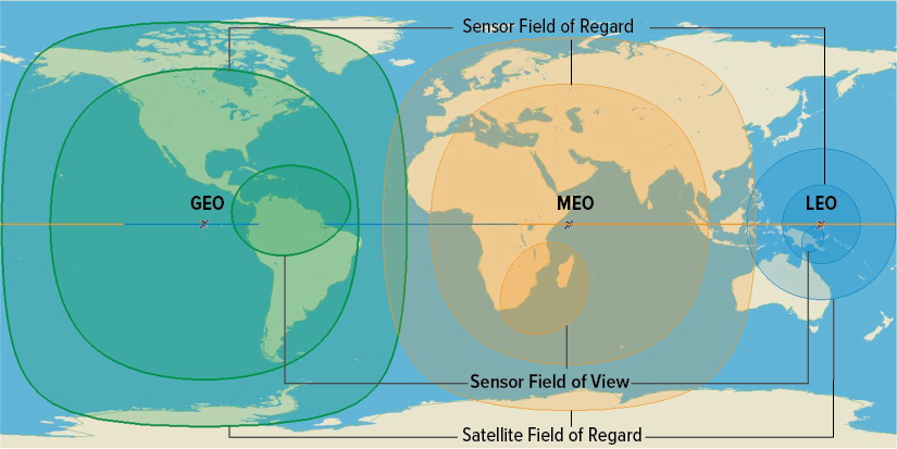
If the viewing angle must be at least 20 degrees above the horizon, the sensor’s field of regard (intermediate circles) is smaller than the satellite’s field of regard (outer circles). A camera with a very wide field of view might be able to view everywhere within its field of regard, but most sensors look at an area that is much smaller than their field of regard at any given moment (smallest oval).
Orbital Inclination Determines What Part of the Earth Is Visible
As a satellite travels through its orbit, it traces out a path on the ground that depends on the relative motion of the satellite and the rotation of the Earth. The inclination of the orbit (that is, the angle the orbit makes relative to the equator) determines how far north and south on the Earth’s surface a satellite travels over in its orbit. A satellite in an equatorial orbit (0 degrees inclination) will orbit along the equator for the entirety of its orbit. As the inclination increases from 0 degrees to 90 degrees, the satellite will trace out a path that reaches a maximum latitude (north and south) that equals its inclination.
For satellites with a wide field of regard, like satellites in GEO, an equatorial orbit can enable access to much of the Earth, including some high latitudes approaching (but not quite reaching) the polar regions. LEO satellites generally have a much smaller field of regard and must have a higher inclination to view high latitudes. Many LEO satellites use so-called polar orbits with inclinations of about 80 degrees or more to cover the full range of latitudes during each orbit.
Paths of Three Low-Earth Orbit Satellites as the Earth Rotates Below Them
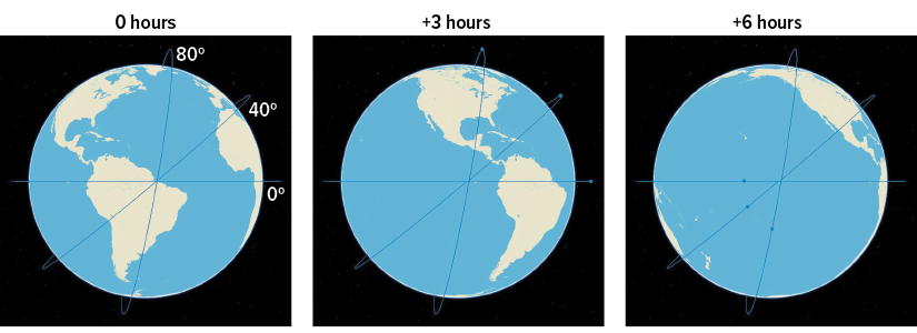
The three tracks shown represent orbits in LEO, each with a different inclination. The locations directly under a given point in the path change from one orbital period to the next as the Earth continues to rotate.
Projection of the Paths of Three Low-Earth Orbit Satellites Over the Earth

The tracks represent the same satellites as those in the figure above during one 90-minute orbit. The Earth’s motion and the satellite’s motion are combined in this projection. The next orbit will trace a different path that begins where this one ends.
Satellite Constellations
A satellite constellation is a collection of satellites in which the satellites’ orbits and positions are coordinated and their collective capabilities are used to accompish a mission. Constellations are typically made up of satellites in several planes with a number of satellites spaced along an orbit in each plane. Satellites can be maneuvered to change their relative position within a plane fairly easily, but movement between planes would require a large amount of propellant and would probably reduce the lifetime of the satellite.7 In some constellations, each plane includes spare satellites that can be moved into position to replace any malfunctioning satellites within the same plane.
Constellation Size and Frequency of Observations
Because a satellite is continuously moving along its orbital path at the same time as the Earth is rotating below it, a single satellite (other than those in geosynchronous orbits) can often view most of the Earth over the course of a few days with a fairly narrow field of regard (or more often with a larger field of regard). For some missions, like environmental monitoring, for which observations need only be made every day or two, one satellite may be sufficient. However, for missions that require global coverage at all times (or nearly all times), multiple satellites need to be combined to form a constellation. Because each satellite in LEO views a relatively small area, those constellations generally need to have many more satellites than do constellations in MEO or GEO to achieve the same coverage.
Satellite Constellation in Low-Earth Orbit at 1,000 Kilometers

A constellation of 72 satellites, separated into 6 planes with 12 satellites in each plane (left panel), provides almost complete global coverage. In the right panel, blue cones show the field of regard of the satellite sensors. Some small gaps between sensors’ coverage exist, primarily in the equatorial region. All 72 satellites are orbiting at an 80 degree inclination.
Orbital Altitude and Constellation Coverage
To make a quantitative comparison of the coverage typically provided by satellites at different orbital altitudes, CBO considered three illustrative examples of constellations that provide comparable global coverage:
- A GEO constellation comprising 4 satellites at geosynchronous altitude, equally spaced in a single plane at 0 degrees inclination (that is, over the equator);
- A MEO constellation comprising 8 satellites at 18,000 km altitude, grouped into 2 planes of 4 satellites each at 45 degrees inclination; and
- A LEO constellation comprising 72 satellites at 1,000 km altitude, grouped into 6 planes of 12 satellites each at 80 degrees inclination (the same constellation as shown in the figure in the previous section).
All three constellations provide coverage of about 90 percent to 95 percent of the globe, on average.8 However, the details of that coverage vary for different latitude ranges, and over the course of several orbital periods, different constellations will access different parts of the globe. In each case, adding more satellites—at additional cost—could increase coverage. For example, the addition of a few satellites at polar inclinations could allow the GEO constellation to achieve full global coverage, as is the case with U.S. early-warning satellite constellations. Adding another plane of satellites could move the LEO constellation closer to providing full global coverage.
Coverage of Three Illustrative Constellations
Percent

The GEO constellation provides full coverage up to about 50 degrees latitude, but none near the poles; the MEO constellation provides full coverage except for a band around 60 degrees latitude; and the LEO constellation provides about 95 percent coverage at the higher latitudes but dips to about 80 percent nearer the equator.
Large Constellations in Low-Earth Orbits
The idea of constellations comprising many satellites is not new, although the meaning of “many” has changed in recent years. The GPS constellation, which has been in operation for decades, consists of about 30 satellites (some of which are on-orbit spares) in MEO. The commercial Iridium constellation, which launched its initial satellites in the late 1990s, operates about 75 satellites (including spares) in LEO for communications. Current concepts for constellations are much larger. For example, the Federal Communications Commission recently approved the launch of 7,500 satellites into a second-generation Starlink constellation and is currently considering an application for an additional 22,500 satellites for that constellation.
Recent Trends in the Use of Satellite Constellations in Low-Earth Orbit
The number of satellites operating in LEO has increased significantly in recent years, driven in large part by investments in commercial constellations. If current commercial plans were fully realized, some of those constellations would comprise thousands of satellites. DoD’s Space Development Agency is also developing plans for constellations of hundreds of satellites, mostly in LEO, for various missions.9
The increase in the number of large constellations is facilitated by several technological developments. Historically, satellites were often built one at a time, using hands-on laboratory processes. Now, however, processes and facilities for mass producing satellites are beginning to be used. In addition, the number of rocket-launch providers has grown substantially, reducing the cost of launching satellites to LEO.
Satellites in Different Orbital Regimes
Thousands of Satellites
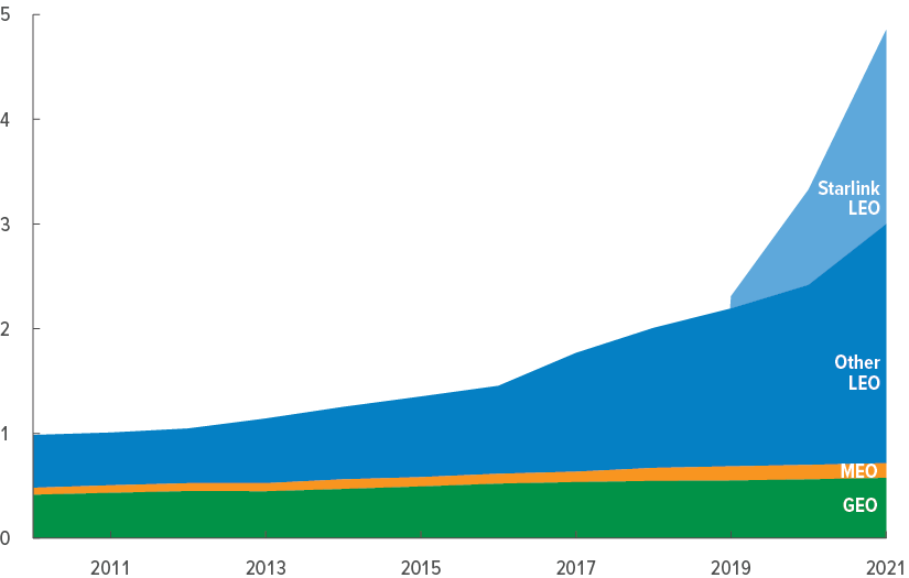
The number of satellites in all three orbital regimes grew slowly but consistently through the mid-2010s. Starting around 2018, the number of satellites operating in LEO began to grow sharply.
That growth has been spurred by so-called megaconstellations built by commercial firms. SpaceX has led the way with its Starlink constellation of communications satellites, which accounted for more than half of the launches of LEO satellites in 2020 and 2021.
High-Resolution Earth-Observation Missions Using Satellites in Low-Earth Orbit
Earth-observation missions often use satellites in LEO orbits because telescopes produce high-resolution imagery more easily at short distances. If a certain resolution is needed to accomplish a satellite’s mission, it can be achieved with a smaller telescope if the satellite is at a lower altitude (and thus generally closer to the observed object).
That is because the ability of a telescope to produce a high-resolution image is related to its ability to distinguish objects that are close together. The wave nature of light limits the smallest angle between objects that it is possible to distinguish, referred to as the diffraction limit. That limit depends on the wavelength ( ) of light being observed (for example, infrared or ultraviolet) and the diameter (
 ) of the telescope’s primary optics (the largest lens or mirror used to focus incoming light), referred to as the aperture of the telescope, and is given by
  .
.
Thus, the larger the telescope (), the smaller the angular separation ( ) that can be resolved (that is, the better the resolution). The angular separation is related to the minimum distance at which two objects on the Earth’s surface can be distinguished from each other (resolved), known as the ground resolution of the telescope, by
  where
where  is the distance between the telescope and the observed object. Thus, for a given telescope aperture, the closer the satellite is to the object, the more clearly it can be seen.10
Smaller telescopes generally cost less than larger ones. Studies by NASA have concluded that telescope aperture is the primary factor in determining the cost of space telescopes.11
Diffraction-Limited Resolution for Various Aperture Sizes
Meters (Log scale)

The larger the telescope, the better (smaller) the resolution. The Hubble Space Telescope has an aperture of about 2.5 m.
The diffraction limits on ground resolution are shown for a wavelength of 500 nanometers (corresponding to light with a blue-green color) near the center of the visible light spectrum, using three different telescope apertures.
Communications Missions Using Satellites in Low-Earth Orbit
Using LEO satellites for communications missions has advantages and challenges. Satellites at lower altitudes can receive a communications signal from the ground and send one back much more quickly than those at higher altitudes. Delays, typically referred to as latency, can reach as much as a quarter of a second for GEO, which can create problems for some applications, like controlling aircraft remotely.
To communicate with someone on the other side of the globe, signals also need to be transmitted from one satellite to another one (and perhaps many more) before returning to Earth. That intersatellite transmission time increases latency for all orbit regimes. Even so, the total transit time (the sum of the ground-to-satellite time, the time for each satellite to process the signal, the time for the signal to travel to the next satellite in the chain, and the final satellite- to-ground time) for a message relayed using LEO satellites is much shorter than for one relayed using MEO or GEO satellites.
Communicating with a satellite constellation is more complex for satellites in lower orbits, however. If a point on Earth is within the field of view of a GEO satellite, it will remain there indefinitely, and communications between a user and the satellite can be established with no need to change satellites; that is why a satellite television dish does not move. Satellites at lower altitudes view any given point on Earth for a shorter time. Those in MEO maintain a given point on Earth within their field of view for roughly 10 hours, so about twice a day, a ground user would need to establish a link with a new satellite to maintain communications. The situation is substantially more challenging for LEO because those satellites maintain a given point in their field of view for only about 10 minutes. In that case, new communications links would need to be established repeatedly if continuous communications were desired.
Time to Transmit a Signal 13,000 Kilometers Across the Earth’s Surface
Milliseconds
The transit time for a message to travel from one location on the Earth’s surface to another location using a satellite constellation varies by the constellation’s altitude.
Satellites in lower altitudes communicate with users on the ground more quickly but require more satellites in the chain. The distance between each satellite is shorter for lower altitude orbits, however. Overall, the total transit time for LEO is about half that of MEO and a quarter that of GEO.
Advantages of Large Constellations in Low-Earth Orbit
Large constellations of satellites provide several advantages over smaller constellations, particularly with regard to damaged satellites. In recent years, DoD has expressed concern about adversaries’ ability to interfere with U.S. satellites. According to public reports, adversaries may be able to temporarily or permanently disable satellite connections using a variety of methods. Damage from such attacks could range from physical destruction (caused by an interceptor missile launched from Earth) to signal disruption (caused by an adversary broadcasting noise to overwhelm, or jam, the satellite’s communications).12 One potential advantage for constellations with many satellites is that their coverage and functionality might degrade more gradually compared with smaller constellations—that is, the loss of a satellite would not result in an abrupt loss of coverage. Moreover, a damaged satellite would pass out of view of an area of interest quickly in LEO, and a functioning one would move into view. Finally, damaged satellites could be replaced fairly quickly. Large constellations might have spare satellites already in orbit, and the operator would probably be producing and launching satellites continually as part of the normal replenishment cycle to replace satellites as they aged out; those operations could be used to replace damaged satellites ahead of schedule.
Large constellations for communications also have the potential to use multiple alternate paths to route a signal around a disabled satellite. However, that type of resilience would require rapid and adaptive methods of managing the communications network and could prove challenging.
CBO modeled coverage degradation in its illustrative constellations by removing the satellite that would result in the largest loss of coverage at each step. In that sense, the agency’s results could be considered the worst-case scenario. However, large-scale attacks in which multiple satellites were compromised at once are also possible. For example, a cyberattack on the satellites’ computers might affect a large portion of a constellation; such an attack would have different effects.
Satellite Coverage Degradation of Three Illustrative Constellations
Percent of Satellite Coverage

As individual satellites are disabled, the coverage provided by MEO and GEO constellations degrades quickly because each disabled satellite represents a large fraction of the constellation total. The larger LEO constellation is more robust against the loss of satellites because many more remain available for the mission even as some are disabled.
Large Constellations and the Growing Number of Debris Objects
Satellites share space with other human-made objects in orbit, known as orbital debris, which come from two main sources. First, routine space operations often leave debris in orbit, including spent rocket bodies and waste from crewed missions. Second, if satellites break apart, they sometimes leave a large amount of debris behind. Satellites break up for a number of reasons. They occasionally fragment as the result of malfunction, are destroyed by collisions with other satellites or debris, or are struck by a missile. The latter categories are more rare, but two notable cases have occurred: a Chinese antisatellite test in 2007, and a Russian antisatellite test in 2021.
Some debris is large enough to be tracked and can potentially be avoided; other debris is too small to be tracked but is still large enough to damage a spacecraft. Once produced, debris can remain in orbit for many years, depending on its altitude and other factors. (Debris in lower altitudes falls out of orbit more quickly.) A NASA study found that debris from a 1985 U.S. antisatellite missile test at an altitude of about 500 km remained in orbit nearly 20 years after the event.13
Generally speaking, if more objects are moving in a particular area, it is more likely that some of them will (or will nearly) run into each other. The United States operates a system to track satellites and debris to warn satellite operators around the world of potential collisions so that they can maneuver their satellites to avoid collisions. Such maneuvers can take satellites out of operation temporarily and require they burn some of their limited amount of fuel, potentially reducing their operational lifetime.
Although satellites can be maneuvered to avoid collisions, debris cannot be. Collisions between debris will probably produce more debris, particularly if the colliding objects are large. If the number of objects in orbit reaches a critical density, a self-perpetuating growth in debris could occur. That phenomenon, known as the Kessler Syndrome, could lead to certain orbits becoming unusable for satellite operations.14
Objects Orbiting the Earth
Thousand of Objects

The number of orbital debris objects has grown substantially, particularly since 2005, in part because of specific events.
The total number of objects in orbit—debris and spacecraft—has roughly doubled in the past 15 years. The vast majority of that increase has been at LEO altitudes.
Interference of Large Constellations With Activities on Earth
Another potential downside of having many objects in low-Earth orbit is that they can interfere with activities on Earth. For example, sunlight reflected from satellites is visible by the naked eye and, according to a recent report, could constitute as much as 10 percent of the visible light from the night sky if planned constellations were fully fielded.15 (Satellites can remain in sunlight much longer than the Earth’s surface does.) Additionally, radio-frequency communications between numerous LEO satellites and between those satellites and Earth could interfere with signals between satellites in higher altitudes and Earth, according to some industry analysts.16 The International Astronomical Union also recently voiced concerns about interference with both optical and radio astronomy from Earth.17 Finally, concerns exist about the environmental effects on the Earth’s atmosphere in the future from the large number of rocket launches and satellites that maneuver to burn up in the atmosphere at the end of their lives.18
Efforts to identify and implement actions to promote sustainable use of space are under way and involve international organizations, governments, and industry.19 Such efforts are challenging, however, because there are currently no legally binding standards of behavior, and any efforts would require voluntary international cooperation.
Costs of Satellites and Constellations in Different Orbits
To field a constellation of satellites over many years, the operator needs to manufacture the required number of satellites, launch them into orbit, and replace them when necessary. An estimate of the long-term costs of fielding such a constellation requires estimates of the production and launch costs of the satellites and the frequency at which the satellites would need to be replaced (a process referred to as a refresh cycle). In this section, CBO estimates the costs to field its illustrative LEO, MEO, and GEO constellations (described earlier in this report) over a 30-year period.
Costs per Satellite
Historically, LEO satellites have generally cost less than those in higher orbits. LEO satellites, because of their proximity to Earth, often have simpler and less powerful payloads that can be supported by a smaller bus. Generally, satellites with smaller buses and correspondingly lower mass cost less than those with higher mass. Additionally, LEO launch costs are lower because less energy is required to lift satellites to lower altitudes.
CBO used average values in DoD’s fiscal year 2023 budget submission to estimate launch costs and assumed that multiple LEO satellites within the same orbital plane could be launched on the same rocket. Typical costs to produce satellites were based on historical examples of DoD satellites and cover a wide range.20 Because there have been no Earth-observation satellites in MEO, the higher value in the range of production costs for those orbits is based on the expected cost of new, more advanced versions of GPS satellites. The actual costs of a MEO Earth-observation satellite could be higher or lower. The costs shown for LEO satellites are consistent with those for satellites in production now and are lower than typical historical costs for LEO satellites. CBO’s estimates include only the cost to produce the satellites and do not include any research and development costs.
Typical Costs for Satellites in Different Orbital Regimes

Communications satellites generally cost less than Earth-observation satellites and represent the low end of the range of satellite costs in each orbit.
Operational Lifetimes of Satellites
LEO satellites generally have shorter operational lifetimes than satellites in other orbits for several reasons. At low altitudes, more residual atmosphere and microscopic debris slow down the satellite and require it to burn more propellant maneuvering to maintain orbit. Debris also gradually degrades the performance of the solar panels. Additionally, LEO satellites spend a large fraction of their orbit in the shadow of the Earth, so their batteries go through multiple discharge/recharge cycles per day, reducing their lifetime.
Efforts to increase the service life of satellites, particularly in LEO, are under way. One approach has been to develop the ability for on-orbit servicing of satellites, using other satellites to change out aging equipment (like solar panels) or to refill propellant tanks. Tests of that approach have been successful, but the practice has not yet been widely adopted. A more incremental approach has been to improve the efficiency of systems, like using electric propulsion for maneuvering instead of chemical rocket engines and improving the efficiency and robustness of solar panels.
However, shorter satellite lifetimes can be useful because they facilitate more rapid introduction of new technology. In programs in which research and development efforts are ongoing, improved versions of satellites can reach orbit more quickly if satellites are replaced more often. CBO did not estimate the costs of such a research and development program.
Expected Satellite Service Life, by Orbital Regime
Number of Satellites

The expected lifetime of satellites varies on the basis of their mission and their orbital regime. Satellites in LEO are designed to last roughly 5 years, on average, although some may last much longer than that. MEO satellites are designed to last roughly 10 years, and for those in GEO, the expected lifetime is about 14 years.
Long-Term Costs of Constellations
Individual LEO satellites generally cost less than those in higher orbits, but more satellites are needed and their shorter lives mean they need to be replaced more often. A comparison of long-term costs of CBO’s illustrative constellations reflects the interplay between these competing factors.21 CBO’s estimates of long-term costs include only the costs to produce and launch the satellites in each constellation. They do not include the costs of research and development (either initial or ongoing), ground systems, or operation. All told, that comparison indicates that the illustrative MEO and GEO constellations CBO considered are less costly over the long run than the LEO constellation.
Satellites, like many other manufactured items, are subject to a phenomenon known as a production learning curve, in which unit production costs decrease as more units are produced.22 How rapidly costs decrease as quantity increases depends on the type of item produced. The era of large satellite constellations is just beginning, and it is not yet known what percentage learning curve (if any) will apply to large quantities. If a 95 percent learning curve applied, unit production costs would decrease by 5 percent each time production doubled, significantly reducing the projected costs of a LEO constellation. (CBO used that learning curve because that curve has applied to other types of satellites the agency has examined.)
Other factors could reduce the difference in costs between constellations of LEO satellites and those in higher orbits, including lower launch costs and longer service lives. Among the orbit categories, MEO and LEO have the highest launch costs per constellation and would benefit most from a reduction in launch costs. If MEO or LEO service lives could be extended, fewer replacement cycles would be needed, and total constellation costs would also be lower.
Costs of Illustrative Satellite Constellations in Various Orbital Regimes

GEO and MEO satellites cost more individually, but because they have longer service lives and fewer are needed to provide full coverage, their constellation costs are lower over the long run.
However, if LEO satellites experienced reductions in unit costs consistent with a 95 percent learning curve, total production costs for LEO satellites would be reduced by about 25 percent, making LEO costs closer to MEO and GEO costs over the long run.
1. CBO’s analysis of the number of satellites in orbit and their characteristics (like mission, planned lifetime, and mass) is based on a database compiled by the Union of Concerned Scientists. See Union of Concerned Scientists, “UCS Satellite Database” (May 1, 2022), www.ucsusa.org/resources/satellite-database.
2. For more information about the Earth Observing System, see National Aeronautics and Space Administration, Project Science Office, “NASA’s Earth Observing System” (September 27, 2022), https://eospso.nasa.gov/.
3. Strictly speaking, the simplified explanation of orbital dynamics given applies only to perfectly circular orbits and neglects the effects of the remnants of the atmosphere. In reality, drag caused by air particles slows the satellite gradually, especially at lower altitudes, which requires the satellite to fire a little rocket every so often to keep the satellite in the proper orbit.
4. For more details, see James R. Wertz and Wiley J. Larson, eds., Space Mission Analysis and Design, 3rd ed. (Microcosm Press and Kluwer Academic Publishers, 1999), chapters 10–11.
5. The calculation of the time a satellite is in view is complicated and varies by altitude, even within one of the defined orbital regimes. The values shown here are for satellites orbiting at altitudes of 18,000 km in MEO and 1,000 km in LEO.
6. To perform such calculations, CBO used the Systems Toolkit software produced by Ansys Government Initiatives.
7. For more information on satellite maneuvers, as well as a more technical and thorough discussion of many of the topics in this primer, see David Wright, Laura Grego, and Lisbeth Gronlund, The Physics of Space Security: A Reference Manual (American Academy of Arts and Sciences, 2005).
8. The calculation of coverage incorporates the constraint that a satellite must be at least 20 degrees above the horizon to view a spot usefully.
9. For further details, see Space Development Agency, “Home” (accessed February 2, 2023), www.sda.mil/.
10. In practice, the diffraction limit for resolution is not achievable because of atmospheric conditions, imperfections in optical components, and other factors, but satellite telescopes can come close.
11. H. Phillip Stahl, “Multivariable Parametric Cost Model for Ground and Space Telescope Assemblies,” Bulletin of the AAS, vol. 51, no. 7 (September 2019), https://baas.aas.org/pub/2020n7i143.
12. See, for example, Brian Weeden and Victoria Samson, Global Counterspace Capabilities, An Open Source Assessment (Secure World Foundation, 2022), www.swfound.org/counterspace; and Todd Harrison and others, Space Threat Assessment 2022 (Center for Strategic and International Studies, 2022), www.csis.org/analysis/space-threat-assessment-2022.
13. M. Matney and P. Anz-Meador, “Solwind ASAT Test Retrospective,” Orbital Debris Quarterly News, vol. 19, no. 4 (October 2015), p. 4, https://tinyurl.com/mvdm7s8e.
14. For more details, see Kelly Kizer Whitt, “Kessler Syndrome of Colliding Satellites Could Make Low-Earth Orbit Unusable,” Earthsky (November 15, 2021), https://tinyurl.com/bdfspcd8.
15. Kelly Kizer Whitt, “Satellites Versus Stars: Which Will Dominate the Sky?” Earthsky (September 28, 2021), https://tinyurl.com/2p839tbs.
16. Joshua Hampson, “A Signal Among the Noise” (May 3, 2017), www.niskanencenter.org/signal-among-noise/
17. International Astronomical Union and others, Dark and Quiet Skies for Science and Society: On-line Workshop Report and Recommendations (January 2021), www.iau.org/news/announcements/detail/ann21002/.
18. Jonathan O’Callaghan, “Emissions From Rocket Launches Could Affect Earth’s Weather Systems,” New Scientist (June 15, 2022), https://tinyurl.com/4f67pw8w.
19. For more details, see Secure World Foundation, “SWF Releases New Infographic on the Importance of Space Sustainability” (February 1, 2022), https://tinyurl.com/bddhyvem.
20. Historical costs correspond roughly to the following actual unit costs: for GEO, the low cost is based on the most recent Wideband Global Satcom satellite and the high cost is for the most recent Space Based Infrared System High; for MEO there were no available DoD analogous communications or Earth-observation satellites, so the low cost is based on the initial versions of the GPS III and the high cost is based on the expected cost of the next generation (GPS IIIF) version; for LEO, the low cost is the average expected cost of the initial group of Transport satellites purchased by SDA and the high cost is the average expected cost for the initial group of the Tracking satellites purchased by SDA.
21. For this example, CBO used lifetimes of 5 years for LEO, 10 years for MEO, and 15 years for GEO. The LEO and MEO lifetimes match the average of satellites currently in orbit. The GEO value is slightly higher than the current average of 14, although it is consistent with some satellites in orbit. The value of 15 was chosen to allow an integer number of refresh cycles in the notional 30-year cost estimate period. The range of costs that CBO used reflect the actual unit costs of the satellites described in the note above.
22. As more satellites of the same type are built, the manufacturer learns how to build those satellites more efficiently. The second satellite in a production run is expected to cost less than the first; the fifth is less expensive than the second; and the ninth satellite is even cheaper. The reduction in cost that comes from learning tapers off as more and more items are built. Eventually, learning becomes effectively exhausted as the number produced becomes large.
AppendixData Sources for Figures and Tables
Effects of Altitude and Initial Velocity on a Satellite’s Trajectory
Congressional Budget Office.
Typical Components of a Satellite
Congressional Budget Office.
Common Orbital Regimes
Congressional Budget Office.
Satellite Characteristics, by Orbital Regime
Congressional Budget Office, using data from the Union of Concerned Scientists’ satellite database.
Field of Regard for Satellites in Various Orbits
Congressional Budget Office, using output data from Systems Toolkit.
Fields of View and Fields of Regard for Sensors and Satellites in Various Orbits
Congressional Budget Office, using output data from Systems Toolkit.
Paths of Three Low-Earth Orbit Satellites as the Earth Rotates Below Them
Congressional Budget Office, using output data from Systems Toolkit.
Projection of the Paths of Three Low-Earth Orbit Satellites Over the Earth
Congressional Budget Office, using output data from Systems Toolkit.
Satellite Constellation in Low-Earth Orbit at 1,000 Kilometers
Congressional Budget Office, using output data from Systems Toolkit.
Coverage of Three Illustrative Constellations
Congressional Budget Office, using output data from Systems Toolkit.
Satellites in Different Orbital Regimes
Congressional Budget Office, using data from the Union of Concerned Scientists’ satellite database.
Diffraction-Limited Resolution for Various Aperture Sizes
Congressional Budget Office.
Time to Transmit a Signal 13,000 Kilometers Across the Earth’s Surface
Congressional Budget Office, using output data from Systems Toolkit.
Satellite Coverage Degradation of Three Illustrative Constellations
Congressional Budget Office, using output data from Systems Toolkit.
Objects Orbiting the Earth
Congressional Budget Office, using data from National Aeronautics and Space Administration, Orbital Debris Program Office, Orbital Debris Quarterly News, vol. 26, no. 1 (March 2022), https://orbitaldebris.jsc.nasa.gov/quarterly-news/.
Typical Costs for Satellites in Different Orbital Regimes
Congressional Budget Office, using data from the Department of Defense.
Expected Satellite Service Life, by Orbital Regime
Congressional Budget Office, using data from the Union of Concerned Scientists’ satellite database.
Costs of Illustrative Satellite Constellations in Various Orbital Regimes
Congressional Budget Office, using data from the Union of Concerned Scientists’ satellite database and the Department of Defense.
About This Document
This report was prepared at the request of the Chairman and former Ranking Member of the Senate Committee on Armed Services. In keeping with the Congressional Budget Office’s mandate to provide objective, impartial analysis, the report makes no recommendations.
Michael Bennett and Corinne Kramer prepared the report with guidance from David Mosher. Kathryn McGinnis contributed to the analysis. Jennifer Shand and David Arthur offered comments. Elizabeth Bass fact-checked the report.
Prashant Patel of the Institute for Defense Analyses and Victoria Samson of the Secure World Foundation commented on an earlier draft. The assistance of external reviewers implies no responsibility for the final product; that responsibility rests solely with CBO.
Mark Doms, Jeffrey Kling, and Robert Sunshine reviewed the report. Caitlin Verboon edited it, and R. L. Rebach created the graphics, illustrated the cover, and prepared the text for publication. The report is available at www.cbo.gov/publication/58794.
CBO seeks feedback to make its work as useful as possible. Please send comments to communications@cbo.gov.

Phillip L. Swagel
Director
May 2023